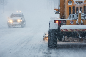
SHEBOYGAN, WI (WHBL) - A major winter storm in the Midwest is expected to dump 2-to-7 inches of new snow throughout Wisconsin – and winds of up to 35-miles-an-hour could cause blowing and drifting. Four to six inches is predicted for the Sheboygan area. The storm has closed airports in Missouri and stranded truckers in central Illinois, and parts of Kansas got up to 17 inches of snow yesterday. It started snowing last night in the Badger State. And by 5:15, Black River Falls had five inches, La Crosse four-and-a-half, and Madison close to three inches. Around two-and-a-half inches fell in downtown Milwaukee by the middle of the night, assuring a difficult morning rush hour for thousands of commuters. The National Weather Service has posted winter weather advisories throughout the state until early evening. But those advisories will continue until tomorrow morning in places along Lake Superior, where 3-to-7 inches are in the forecast. Other parts of the state could also get some freezing rain this morning, as temperatures get close to the freezing mark. Highs of around 30 are expected both today and tomorrow. Most of the precipitation is supposed to clear out tonight, but there’s a lingering chance of snow showers in the forecast for tomorrow.